
Our friend Mikeala, who lives in Longmont, devised this route.
Many of these trails can be found on other routes posted on the site, but because a few trails were new, and when put together this way, we had such a great time- we just had to share!
There are some relatively new singletrack trails branching off the Coal Creek Trail in Erie near Vista Point Open Space Park. All of them are beginner-friendly and genuinely fun. Because they sit right off the main trail, you can take them—or skip them—depending on your mood and trail conditions. We wouldn’t have wanted to miss them; they added an extra dose of joy to an already great route.
Our snack stop, Moxie Bread on Main Street in the quaint downtown of Louisville, was an excellent choice. We grabbed coffees and sampled several pastries, all of which we’d recommend. (They even had a few gluten-free treats for those with dietary restrictions.)
The Teller Farms area, starting around mile 28, was another highlight, featuring fairly smooth dirt trails and spectacular mountain views.
The East Boulder/Gunbarrel Trail at the end of the route delivered more great scenery, a tough climb, and a fast, exhilarating descent. While the trails weren’t crowded, we did pass other bikers, hikers, and even a few equestrian riders along the way.
A few of the roads connecting the trails at the beginning had some car traffic, but ample shoulder space made riding single file feel comfortable.
Do this ride if you want a terrific variety of easy gravel terrain with a delicious snack stop- perfect for playing bikes with friends on a warm winter day!
We started and ended this route from the LoBo Trailhead in Lefthand Valley Grange Park at the corner of Niwot Rd and N 83rd. There are about 30 parking spots and public vault toilets here, though fair warning, they weren’t the cleanest bathrooms.
Many of the trails are exposed, making this a perfect route for a warm winter day. Heat and or mud could make this route less fun, so always consider the weather and recent conditions.
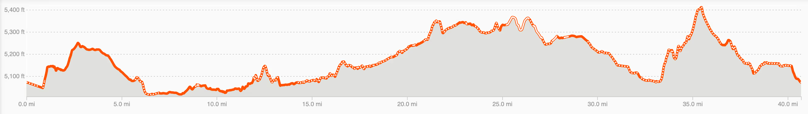
Total elevation of the route is just under 1,800 ft, which is not much overall, but expect a few little punchy inclines here and there.
There are several places to choose from in terms of spots to stop for food and beverages. We chose to stop at Moxie Bread on Main street in the quaint downtown of Louisville (which is right on the route at approximately mile 22). It has nice outdoor seating, good sandwiches, pastries and coffee. (LGBTQ friendly too 🙂🌈)
Another option is Jeannots Patisserie at the corner of 95th and Arapahoe at approximately mile 26.5
 Laura & Rose
Laura Karpinski and Rose Barcklow are the creators of Gravel Bike Adventures. Click on the About page to learn more about them.


