
This route is perfect for bikepacking as there are several options for dispersed or campground camping, plus a few places to stop for food and water. We chose a dispersed campsite and did the whole route in one go, but there are great camping spots in the middle of this route near the end of Tolland Road and also a few miles up Rollinsville Pass.
The first couple of gravel roads (which comprise 65% of the route) offer what we love about gravel riding in the high country of Colorado: wide dirt roads that are generally quiet, with low car traffic and incredible views of rivers, mountains, and animals. We particularly enjoyed Magnolia Drive (132), 97, South Beaver Creek Road (11), and Lump Gulch.
There is no singletrack, and none of the gravel is technical.
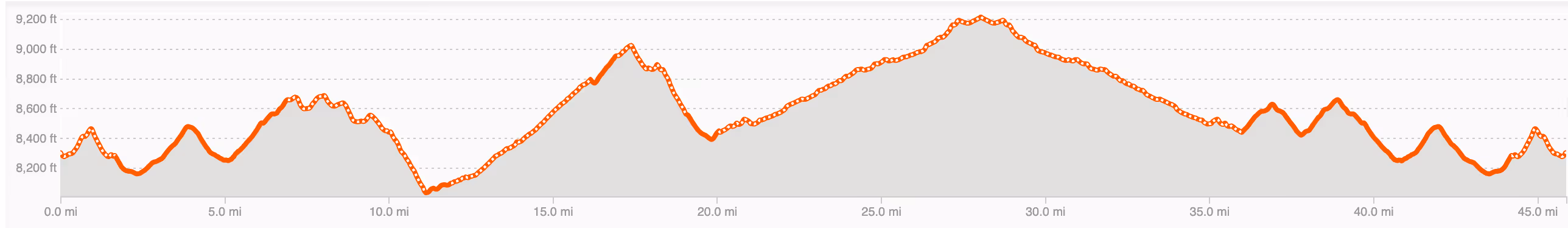
The climbs are generally mild grades, with most inclines between 2–7% - nothing too terribly steep!
While we will always prefer the gravel roads, as far as pavement goes, the Peak to Peak Highway is not all that bad. There is a wide shoulder, the pavement is in good condition, it's rare to see a semi and the downhill sections are honestly pretty fun to bomb down!
The out and back section on Tolland/East Portal Road has iconic views of South Boulder Creek, the railroad, the historic yellow Tolland schoolhouse and the majestic snow-capped mountains of the James Peak Wilderness. The turn around point is the famous East portal of the 6.2 mile long Moffat Tunnel which was built in the 1920's and cuts though the Continental Divide.
Although Tolland Road is not to be missed on this route, we biked it on a Saturday afternoon on a holiday in June and the road was quite busy with car traffic. Many cars quickly passed us and stirred up quite a bit of dirt into the air. On the way towards the Moffat Tunnel, while staying to the right on the road, washboards were not that bad. On the way back, on the other side, the rough road was unavoidable and uncomfortably annoying as washboards generally are. If you want less of this experience, try to doing this on a weekday.
Do this ride if you want a great Colorado high country mixed-surface route that is perfect for a day trip or bikepacking.
We started this ride from a dispersed camping area on Forest Service Road 332 which is just off Sugarloaf Road. There were multiple places to camp as it is on Roosevelt National Forest Land. We were lucky to snag a spot that was less than a mile down the road. Note: this was the roughest of the roads on the route. It is bikeable but also has punchy hills and the surface is chunky with lots of potholes.
(Our original plan was to camp in the first-come-first serve West Magnoila Camping area but it was full when we arrived. That dispersed camping area is essentially right off the route and would allow you to cut off miles, but you would also miss the town of Nederland.)
There are actually a couple of good spots to stop on route if you want food or coffee. The town of Nederland will be passed though twice- at the beginning and again right before you finish. Nederland has gas stations/convienient stores, bakeries and restraunts. Notable places are: Newmoon Bakery and Cafe, and Crosscut Pizza. In Rollinsville we recommend Salto Coffee (which is approximatley at the halfway point). Note: hours can be surprising and irregular in mountain towns. Call or check hours of operation especially if you are bikepacking and are relying on places for essential stops.
Don't forget that you are starting from high altitude on this ride. Nederland sits at 8,235 feet (2,510 meters) above sea level. Expect to feel a little extra winded, remember to carry and drink extra water and always check the weather and anticipate rapidly changing temperatures and conditions.
 Laura & Rose
Laura Karpinski and Rose Barcklow are the creators of Gravel Bike Adventures. Click on the About page to learn more about them.


