
You'll follow some park trails along the Tolt river that connect you to the Snoqualmie Valley Regional Trail (SVT), which you ride for about 14 miles in total during this route. The SVT is a super smooth and non-technical dirt packed trail that runs alongside the Snoqualmie River. It follows the historic route of the Chicago, Milwaukee, St. Paul & Pacific Railroad and offers scenic views of the river, Mt. Si, farms, forests, and wetlands. In summer, it is mostly shaded by dense forest, has trees dripping with moss, and the river is a gurgling, crystal clear stream.
If you are on the look-out you can spot many varieties of wildflowers such as blackberry, elderberry, buttercup and wild rose.
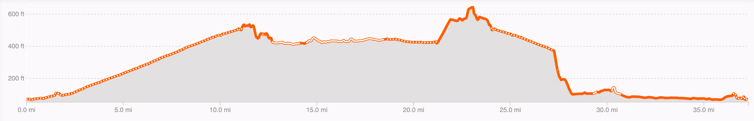
Snoqualmie Falls, a famous 270-foot waterfall and one of Washington state’s most popular attractions, was a unique and awesome scenic stop on this route.
The large majority of the paved roads have the low-traffic feel of a 100% gravel route, especially the roads between Fall City and Carnation. You'll bike past well-kept, healthy u-pick farms of berries, fruits, vegetables and colorful flowers of seemingly infinite varieties. We felt a bit like we had been transported back in time when things were refreshingly slower, more quiet and simple.
The route ends with a cool (recently renovated) 500-foot suspension bridge that spans the Snoqualmie River and connects the Tolt-MacDonald Campground to the parking lot where you began. You must dismount and walk, but it gives you time to really savor the view from the vantage point of the bridge.
While we certainly recommend the stop at Snoqulamie Falls, it is the busiest and most congested area on the route. Keep your eyes peeled as you bike in and out of the parking lot and dismount your bike to go out to the observation deck. (The distance between the free parking lot and the viewing platform is approximately 200 feet.)
Pro tip: opt to do this on the weekday if you want to avoid the more intense crowds.
At approximately mile 20.6, the SVT goes over a bridge that ends in stairs. It is not super well marked, so be prepared to stop at the end of the bridge and know you will need to carry your bike down a flight of stairs to the road.
Do this ride if you want to explore King County, Washington on relatively easy forested rail-trails, see Snoqualmie Falls, and be charmed by small-town businesses and local berry and flower farms.
We started from the Tolt-MacDonald Park and Campground. There is plenty of public parking here as well as a few port-a-potties.
Keep in mind that the Tolt-MacDonald Park is also the site of the Carnation Farmer's Market on Tuesday's from 3:00-7:00 pm, which could affect parking and crowds.
The park features a "beach" at the confluence of the Snoqualmie and Tolt Rivers which is perfect for taking a dip in the water or relaxing on the shore post-ride. (This is also high-quality salmon habit, so during the fall, visitors can observe chinook salmon spawning in the river!)
Should you want to camp, The park also features six yurts overlooking the river and seasonal camping for RVs, tents, and two large-group campsites - all with fire pits. Use their online reservation tool to reserve a camping site.
There are public bathrooms in several places along the way: at approximately mile 7.6 on the SVT, at Snoqualmie Falls (mile 12.25), and at Aroma Coffee (mile 29.25).
We love a mid-ride coffee stop and for this route we chose Aroma Coffee, which had been recommend to us by our friends at the Cascade Bicycle Club. The cafe is located in a cute house in Fall City which is full of small-town charm. They offer handcrafted drinks and locally-sourced food and pastries. Yum!
 Laura & Rose
Laura Karpinski and Rose Barcklow are the creators of Gravel Bike Adventures. Click on the About page to learn more about them.


