
This route is the "Smol" course from the Boise Gravel Gala, Boise’s Premier Gravel Event.
If you want to do this with support and other riders who are suffering and smiling alongside you, check it out!
They do the event yearly in late September and say that is it not a competition, but "it’s an end-of-the-season, I’ve-been-riding-all-summer-and-can-tackle-this event, where we get together, have a hard day on the bike with old and new best friends, all supported with the best aid stations ever. And then, when you’re done, there’s a big party with beer and food."
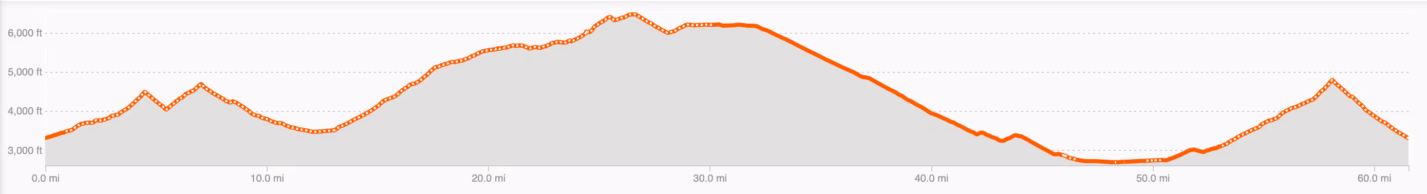
The longest course they offer is 92 miles with 11,476 feet of elevation gain. 😮 🤯
While the climbing on this route might be long and tough, we found the forest roads getting from Robie Creek to Bogus Basin to be really enjoyable.
The road surface was in very good condition- largely non-technical and relatively smooth packed dirt.
In this area, the forest was dense and healthy with plenty of shade, and even though you share the road with cars, traffic was very light.
Near the top, the views were spectacular!
The first longer down hill between miles 7-13 before the BIG climb starts was fast and fun!
We enjoyed stopping for a mid-ride coffee and much-needed food at about mile 50 in the city of Boise. Navigating the city was easy with bike lanes on most of the streets we were on.
There are a plethora of places to choose from when it come to food options. We chose to stop at Form & Function coffee which had excellent coffee and food.
The last climb from Boise back to the car through Noble Reserve, had much different scenery than the earlier part of the ride. It was more exposed (and hot!) with undulating green slopes of grass and sagebrush.
This route is very HARD because of the huge amount of climbing it entails. You get most of the elevation in the first 27 miles (approximately 6,200), but when you head out from Boise, you still have about another 1,500 feet of climbing to go! Ouch- bring all your fitness and your climbing legs and lungs.
While a long 15-mile paved downhill sounds really nice after all that climbing, we were quite frozen by the time we got down to Boise. We brought warm layers and gloves and it was a warm day in late June, but it is a looooong time to coast at high speeds in sweaty clothes. 🥶
Maybe we were just tired and hot by the end of the day, but the last descent on Shaw Mountain Road back to the car was our least favorite. The road was sleep, rutted and loose requiring a lot of focus and attention that we just barely had the effort for.
Do this ride if you want a massive climbing challenge on remote dirt roads just out outside of the city of Boise. Preferably, wait till late biking season when your fitness is at its prime!
We parked and started at the intersection of Robie Creek Road and Shaw Mountain Road near the Robie Creek Volunteer Fire Department. We chose to start here so that we would have the city of Boise as a refueling stop during the ride. There is a large dirt pull-off area to park (make sure you DO NOT park on the Fire Department property!)
The nearest public bathrooms to where we started is at Robie Creek Park (about 1.3 miles drive/bike away).
There is next to nothing in the way of services between the start of this ride and Bogus Basin Ski Resort. Make sure you have enough fuel and water on board to get you up 6,000+ feet of climbing in the first 27 miles. The resort is open in the summer with lift-served mountain biking and a mountain coaster, so services (food, beer and coffee) are available before Boise should you want/need them.
In late June, the temperature changes during this ride were no joke! We started out early, so it was a chilly start. Climbing made us sweaty but the elevation of the ski resort is about 6,500 feet above sea level and temps we cool up there, so the descent felt frigid. Back in Boise, it was a warm summer day and the climb up Shaw Mountain Road was exposed so we roasted on this section.
There are a plethora of places to choose from if you want to stop for food or beverages in Boise. We chose to stop at Form & Function coffee cafe located in the Sparrow hotel. Beyond great coffee they had pastries, all-day breakfast burritos, toasts and bowls. They have a lovely outdoor patio where you can eat and relax while keeping an eye on your bikes.
 Laura & Rose
Laura Karpinski and Rose Barcklow are the creators of Gravel Bike Adventures. Click on the About page to learn more about them.


