
This route is brought to you by Kymberly Byers, a self proclaimed “vagabond bikepacker” whose passion is to ride the back roads to the roads less traveled. Photo Credits: Kymberly Byers
The views and scenery on this route are truly spectacular!
Table Rock and Lindy Point have breathtaking vistas you won't want to miss. You will have earned these views too, which adds an element of pleasure to the moments of wonder as you take in the vastness of the valley below your feet. (At multiple points while biking, you can recognize from across the valley where you have already ridden.)
Water falls!!! There are many including Douglas Falls and the beautiful Blackwater Falls. (It is a slight detour/hike to see the view, but it is totally worth it.)
The down hill section on the bike trail is not only a visually wonderful experience, but it is a lot of fun and a great way to begin this route.
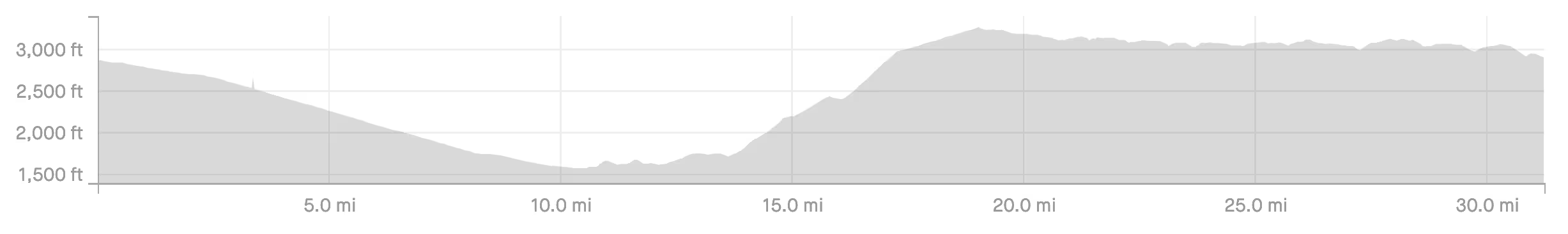
This route earned a difficulty rating of 4 because of the 1,700 foot climb with 12-15% grade on forest service road 244. Also, miles 19 through 25 are very chunky and challenging, complete with a creek crossing.
Miles 29 through 32 are on a busy paved road but with good visibility and wide lanes. (Most vehicles were very respectful.)
There is exactly zero places to resupply until you reach Davis with 3 miles left to the end. (FYI- those last three miles are not easy, so I do recommend stopping at the gas station.)
Do this ride if you want to experience some of the best views in West Virginia and love waterfalls.
You will be on a rural route with no resupply/bathrooms after you leave Thomas. The only water available is creeks and rivers, so bring plenty of hydration or pack a water filter.
The majority of this route is gravel with a little bit of pavement between he bike trail and forest service road 244, and pavement after Lindy Point. Don't get mislead to think it will be easy with about 30% pavement. The other 70% is relatively tough gravel miles.
At the beginning or end, I recommend stopping at Tip Top Coffee in Thomas - it's a charming coffeehouse featuring specialty java drinks, baked goods, light bites and a full bar.
 Guest: Kymberly Byers
Kymberly Byers is a self proclaimed “vagabond bikepacker” whose passion is to ride the back roads to the road less traveled.
Her current mailing address is in Fort Wayne, Indiana, but she gets around quite a bit and who knows where she’ll land next!
Kymberly began bikepacking in 2017 and has been doing multiple trips a year since. In 2020, She bikepacked 100 consecutive days from Fort Wayne Indiana to the Headwaters of the Mississippi to the Badlands, Black Hills, Devils Tower, over the Bighorn mountains, to Yellowstone, made a lap around the Tetons and many points beyond. She also completed smaller trips along the Gulf coast, Texas, the Upper Peninsula of Michigan and more- 26 states in 2020 alone!
You can learn more about Kymberly and her 2020 bikpacking trip on the Girls Gone Gravel Podcast: https://soundcloud.com/girlsgonegravel/rebroadcast-strangers-self-worth-with-kymberly-byers-episode-25
“Basically, I just want to ride and experience the vast beauty of our earth. If I can share my experiences, then all the better.”


